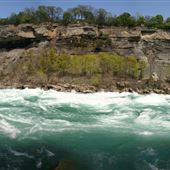
Location ID: #2077
43 photos
Bluffer's Park includes the Scarborough Bluffs, Bluffer's Park Beach, and Bluffer's Park Marina. It has two sections: an upper meadow and a waterfront park. Bluffers Park (waterfront) features a lake, a rocky shoreline, a sandy beach, a yacht club ...
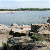
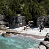
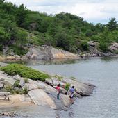
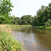
Location ID: #1817
26 photos
Waterfront Park & Beach. Rocky shoreline beach & peninsula.
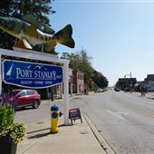
Location ID: #5101
121 photos
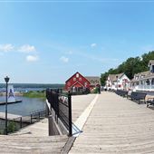
Small waterfront fishing village on north shore of Lake Erie. Now part of The Municipality of Central Elgin. Working harbour. Summer tourist destination. Home of Port Stanley Terminal Rail, an operating tourist railway. Main Street and Bridge Street ...
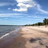
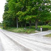
Location ID: #2076
26 photos
Stretch of public beach and cottage. Small walkways lead to beach. No public parking area. Lake front cottages.
Location ID: #17696
23 photos
Bon Echo Provincial Park is a provincial park in southeastern Ontario north of Kaladar, approximately 6 kilometres north of Cloyne. Bon Echo features several lakes, including part of Mazinaw Lake, the seventh-deepest lake in Ontario. The park is ...
Location ID: #2216
46 photos
National park with diverse geography including wetlands, rugged cliffs and dry alvars. 155 sq km. Alvars are flat areas of limestone bedrock with moss/lichen. Broad leaf forests of maple, oak, hickory & walnut. Limestone cliffs including ...
Location ID: #2510
37 photos
Roundabout. 2 parking lots. Washroom and change room structure at the foot of Cherry St. Lifeguard station. Natural growth and treed area. To the west is an off leash dog park. The most western point of the beach (“Eastern Channel”) has a view ...
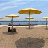
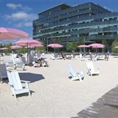
Location ID: #11411
14 photos
City beach with permanent yellow umbrellas and muskoka chairs on white sand. Across from island airport. Small boardwalk. Marina to the east of beach.
Location ID: #10811
14 photos
8500 square metre (2 acre) urban beach along the Jarvis Slip. Designed by Claude Cormier Architects Paysagistes Inc.. Whimsical and industrial feel. Located between the new Corus Quay headquarters (glass building) and the Redpath Sugar Factory at ...
Location ID: #3861
49 photos
Jack Darling Memorial Park is a large mature park in southwest end of Mississauga with picnic areas, waterfront trails along Lake Ontario, and lovely old treed areas that can accommodate up to 1,000 people. Waterfront is long with rocky and sandy ...
Location ID: #5432
26 photos
Provincial Park near Picton. 1,509 hectares. Giant sand dunes and beaches form two of the largest freshwater sandbars in the world. Camping facilities include washrooms, showers store, laundry facilities, visitor centre, and boat rentals.
Location ID: #2220
42 photos
Long beach / parkland that runs west of the city along the lake. Bike paths, walking paths, boardwalks, parkland, swimming pool, playground, large parking lot, sandy beach and condos nearby. Budapest Park is situated between the Bathing Pavilion ...
Location ID: #6478
55 photos
Popular 4-season resort town on Nottawasaga Bay, southern end of Georgian Bay. 14 km of white sandy beaches on the bay and river. Approx 15,000 population year round. Wasaga Beach has six beaches. Beaches numbered 1 – 6 from east to west. One ...
Location ID: #12690
116 photos
Killbear Provincial Park is a park located on Georgian Bay in Parry Sound District near the town of Nobel. Activities in the park include camping, swimming, boating, cycling and fishing. The park's proximity to southern Ontario makes it very ...
Location ID: #3729
26 photos
Large waterfront park. Small waterfall, marina ponds, beach. Fly casting and model boating ponds. Fishing pier. Fully-accessible public boat launch ramps and moorings. Public phones near east and west washrooms and bus loop. Humber Bay Park ...
Location ID: #17241
50 photos
Located along the shore of Lake Ontario in Oshawa, Lakeview Park is a community park with mature landscape setting, views of Lake Ontario, and is connected to recreational trails, Joseph Kolodzie Oshawa Creek Bike Path and the Waterfront Trail, ...
Location ID: #2470
12 photos
Beach runs along southern shore of the Island off Lake Ontario. Change rooms. Lifeguard station. Pier extending into lake.
Location ID: #6237
247 photos
Toronto Islands include Centreville, Centre Island, and Algonquin. Centreville is an amusement park for young children that features scaled down period buildings, water play area, log ride, train ride, and working farm. Centre Island has docks, ...
Location ID: #15761
86 photos
Situated on 6,330 acres along the shores of Lake Huron, Pinery Provincial Park has 10 km of beach and nature trails; fresh water coastal dunes; Oak Savanna ecosystem; a general store, restaurant, laundromats, picnic shelters, a year-round Visitor ...
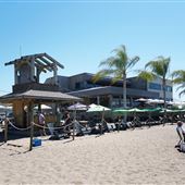
Location ID: #20296
26 photos
Waterfront restaurant with large indoor dining room and deck overlooking palm-treed beach. The dining room has open duct work, hardwood flooring, and large windows overlooking the beach and water. Small separate dining area, interior sit-up bar and ...

Location ID: #13559
36 photos
The park covers 3 km of sandy beach on Lake Superior. Camping available, washrooms.
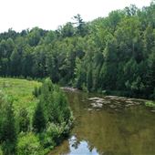
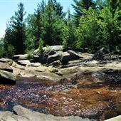
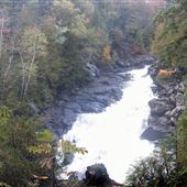
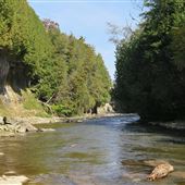
Location ID: #3216
42 photos
On the Bruce Trail. Credit River as it narrows and rushes through a deep gorge plunging over a waterfall. Geological features that were deposited or carved out by retreating glaciers such as kame hills and kettle lakes. Upland rolling pasture ...
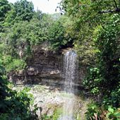
Location ID: #2111
4 photos
Classical waterfall, height 58 ft. Can be accessed at top from Rock Chapel Road or from below at Borer’s Falls Conservation Area off York Rd, a hike of 2.5 km. Natural area which is part of escarpment. Wild and remote looking. Spectacular falls ...
Location ID: #10058
37 photos
Located just east of the junction of Hwy 17 and 17B. Small paved parking lot off Hwy 17. Part of a larger campus trail system adjacent to Canadore College and Nipissing University. The falls are a long cascade about 100 metres high with a crest of ...

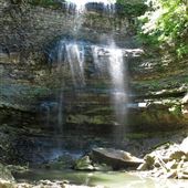
Location ID: #5544
43 photos
Ribbon waterfall height: 17 metres/56 feet and width: 8 metres/27 feet. Strong continuous flow fed by springs at headwater. Situated on Bruce Trail on private property. Easy access from Lions Club Road. Maplewood Conference Centre near by for ...
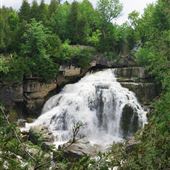
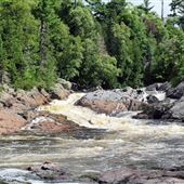
Location ID: #4279
84 photos
Felker's Falls is a 22 metre high ribbon waterfall. The Felker’s Falls Escarpment Valley is a small bedrock gorge cut into the face of the 725 km long Niagara Escarpment.
Lower waterfall is 2 minutes off Quigley Rd in Felker's Falls Conservation ...
Location ID: #3676
25 photos
Developed in the 1950s and overlooking the Hogs Back Falls on the Rideau River, the park consists of 20 acres with heritage concession stand and washrooms. Originally a gentle set of rapids, the falls were created with the construction of the dam. ...
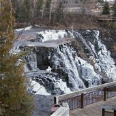
Location ID: #14992
76 photos
The conservation area covers 200 hectares and includes 7.5 km of trails covering various types of escarpment terrain including forest and rock. There is an 18 metre cascade waterfall created by the Sydenham River meeting the escarpment. There is a ...
Location ID: #3944
14 photos
Falls, parking lot, platforms, walkway, etc. Water runs west to east over falls Canyon to the east. River flow is much higher in summer months. No access to bottom of falls except further downstream.
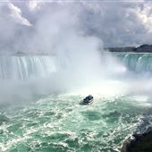
Location ID: #4700
15 photos
A massive waterfalls on the Niagara River which straddles the Canadian and US border. The Horseshoe Falls on the Canadian side drops 173 ft and is 2, 600 ft wide. Expansive observation deck, souvenir stands, views from table rock roof, lower deck ...
Location ID: #16290
19 photos
Niagara White Water Walk formerly known as Niagara Great Gorge Adventure allows visitors to walk along a 1/4 mile long wooden boardwalk at the narrowest portion of the Niagara Gorge where the river is the fastest, classified as Class 6. There is no ...
Location ID: #5198
19 photos
Located on the Oxtongue River about 2 km upstream of Oxtongue Lake. Despite the proximity to Algonquin this is a park in its own right. Woodland trails, jagged rock formations. On Highway 60 at the western edge of Algonquin Provincial Park.
Location ID: #2530
15 photos
Chippewa River visible from Highway 17. Trail accessible from parking lot off highway. Views to upper and lower falls and Chippewa River.
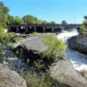
Location ID: #3046
192 photos
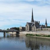
Location ID: #18063
39 photos
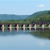
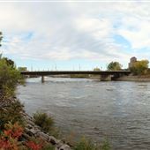
The Grand River at Brant's Crossing with historic rail bridges, public spaces, waterfront trails and skateboard park.
Location ID: #2731
17 photos
Grassy riverbank. Housing backing onto river. Old Derry Road Steel arched bridge. Beside Conservation lands. 2 lane bridge at Derry Rd.
Location ID: #3272
4 photos
The French River flows 110 kilometres (68 mi) from Lake Nipissing west to Georgian Bay. The river largely follows the boundary between the Parry Sound District and the Sudbury District, and in most contexts is considered the dividing line between ...
Location ID: #2283
175 photos
City consists of 3 smaller communities: Hespeler, Galt and Preston. Main street in Galt is Water Street, running along the Grand River. There are 3 main bridges crossing the Grand River in the downtown core; 2 are cement structures. A large ...
Location ID: #6363
37 photos
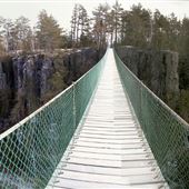
Private campground, woods, park canyon and mountain area. Canyon is 300 ft on both sides and about 1/2 mile long with access to top and bottom by dirt roadway. Small river and lake at bottom of canyon, staircase access on both sides. Suspension ...
Location ID: #13440
52 photos
Rail line covers 150 miles between Sudbury and Temiscaming, Quebec. Rail travels through small towns, agriculture and pasture lands, forested and bush with rocky outcroppings, level dirt road crossings and alongside a major highway. Large rail ...
Location ID: #5022
7 photos
River, shoreline, topography typical of the Canadian Shield. Located on Henvey Inlet First Nation lands.
Location ID: #9685
23 photos
Former St Catharines Rowing Club
Location ID: #6305
17 photos
Steep winding road, tree lined, parkland, two bridges.
Location ID: #9948
16 photos
Built by the National Capital Commission in 1973. It’s named after the historic Portage Trail around the Chaudiere Falls and Rapids which ended near the present location of the bridge. Connects Wellington St in Ottawa to Boul. Alexandre-Tache in ...
Location ID: #18623
27 photos
Built in 1853 by George Wilkes, Mayor of Brantford to provide water to his Holmedale Mill. The dam reaches across the Grand River and has the Grand Valley Trail running along the south side. The paved SC Johnson Trail also runs along the south side ...
Location ID: #6230
48 photos
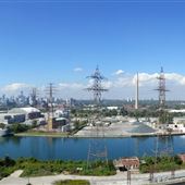
Toronto's Port Lands (also known as Portlands) is an industrial waterfront area located on the southeast end of downtown Toronto. Includes water channels, bridges, factories, industrial yards, old warehouses, former power plants, parking lots, ...
Location ID: #3530
34 photos
Hamilton harbour, ports, docks, bridges, parks, beaches and Port Authority Building. 31 sq km natural harbour, 223 hectares. 550 acres mixed industrial commercial and recreational land. Over 11,000 m of docking facilities. Piers, warehouses & ...
Location ID: #18068
54 photos
The Oshawa Port is owned by the Hamilton Port Authority, and includes mooring for multiple large ships. The Port is located beside Lakeshore Park in Oshawa, and includes a long pier between the Park beach and the Harbour, various silos for salt, ...
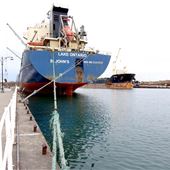
Location ID: #5101
121 photos
Small waterfront fishing village on north shore of Lake Erie. Now part of The Municipality of Central Elgin. Working harbour. Summer tourist destination. Home of Port Stanley Terminal Rail, an operating tourist railway. Main Street and Bridge Street ...
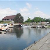
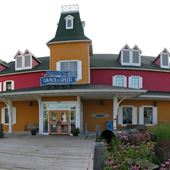
Location ID: #1957
54 photos
Lakefront residence, harbour, waterfront, stone beach, parks, pier, dam, town hall, main street with commercial strip. Small town looks and period buildings.
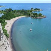
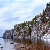
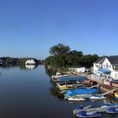
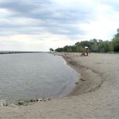
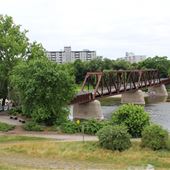
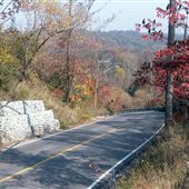
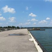
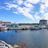
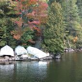
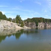
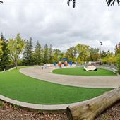
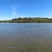
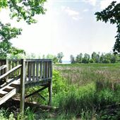
Location ID: #2077
43 photos
Bluffer's Park includes the Scarborough Bluffs, Bluffer's Park Beach, and Bluffer's Park Marina. It has two sections: an upper meadow and a waterfront park. Bluffers Park (waterfront) features a lake, a rocky shoreline, a sandy beach, a yacht club ...
Location ID: #2206
41 photos
Harbour in Oakville waterfront area with a lighthouse pier, boardwalk, shops, and park. Large marina and harbour with upscale docking for boats. Beach at one end.
Location ID: #3193
9 photos
In the heart of historic downtown Kingston. In front of City Hall. Behind Shoal Tower. 400 slip finger docks.
Location ID: #1819
20 photos
Large, private marina and yacht club. Docks, clubhouse, refueling station, repair area. Gated entrance.Descriptions from the corporate website. The present clubhouse was built in 1976. Docks, boardwalks, sailing, school building, railway system, ...
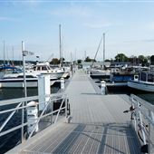
Location ID: #19511
29 photos
This large, private marina with sailboats and speedboats docked through spring-summer. Picnic pavilion. Gated area.
Location ID: #5179
217 photos
A 10-acre site located along the shoreline of Lake Ontario. Concrete boardwalk / walkway running east to west along waterfront at water's edge. Tour boats and tall ships moored along the pier. Buildings just to the north of lake include Queens ...
Location ID: #7786
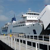
118 photos
Passenger/Car ferry travels between mainland Tobermory and South Bay Manitoulin Island from May to October. In the off season the Chi-Cheemaun docks in Owen Sound. Largest great lakes ferry can carry 638 passengers and 143 cars. Ship's features; ...
Location ID: #9878
72 photos
Wharf with multiple docks. Steam ship cruises, luxury hotel and condos, large modern museum and boathouse. 2 new large restaurants with waterfront patios or decks. Pavilion, gazebo, 2 ticket booth structures for cruises and gift shop. Boardwalk, ...
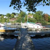
Location ID: #7484
12 photos
Inland harbour, on a narrow strip of the Bay of Quinte. Houses back onto harbour area are elevated by a large hill. Picton Harbour Inn backs onto the harbour. Large portion of the marina is privately owned.
Location ID: #2849
86 photos
Reconstructed British Naval depot and military garrison circa 1817-1856. Original officers' quarters. Reconstructed 19th century schooner HMS Bee moored at King's Wharf.
Location ID: #2353
12 photos
2 lakes located across from each other, North and South of Hwy 60. Canoe Lake has large dock, parking and park buildings. Smoke Lake has small dock and parking.
Location ID: #3216
42 photos
On the Bruce Trail. Credit River as it narrows and rushes through a deep gorge plunging over a waterfall. Geological features that were deposited or carved out by retreating glaciers such as kame hills and kettle lakes. Upland rolling pasture ...
Location ID: #3506
41 photos
Haliburton Forest is a 100,000 acre, privately owned forest within central Ontario. Only 2.5 to 3 hours north of Toronto and 3 hours west of Ottawa. Features include rolling forested hills, rock faces, 100 lakes, over 400 waterways, beaver ponds, ...
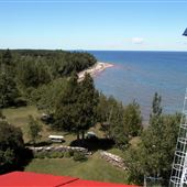
Location ID: #8524
38 photos
Woodlands and cottages surrounding Georgian Bay waterfront.
Location ID: #12692
62 photos
Established in 1959, the park is approximately 2,500 hectares in size. Surrounded by Clear Lake, Grundy Lake, Gurd Lake and Gut Lake, the park offers kilometres of hiking trails through dense forests of northern pine and spruce trees. Glacial ...
Location ID: #14088
111 photos
79 acre (32 hectare) tree-covered conservation area. Most popular features two acres of a former limestone quarry, encircled by sheer cliffs of heights up to 40 feet, as well as a beach and mulitple picnic areas. Gatehouse leading into the ...
Location ID: #3964
173 photos
397 ha. Established in 1960. On the Niagara Escarpment in Milton. Dam and reservoir built for flood protection and to regulate stream flows in Sixteen Mile Creek. Beach area for swimming. Escarpment with cliff views.
Location ID: #15761
86 photos
Situated on 6,330 acres along the shores of Lake Huron, Pinery Provincial Park has 10 km of beach and nature trails; fresh water coastal dunes; Oak Savanna ecosystem; a general store, restaurant, laundromats, picnic shelters, a year-round Visitor ...
Location ID: #2123
5 photos
Small lake off the highway in the Haliburton Highlands. Similar to the Adirondacks.
Location ID: #3595
72 photos
Situated on 169 hectares with two kettle lakes, wetlands, fields and easily accessed forest. Trails throughout the area cross a variety of terrain. There is a heated swimming pool, splash pad, playground and Medicine Wheel Garden. The Treetop ...
Location ID: #4116
43 photos
Public park with waterfront promenade connecting to a crescent shaped suspended boardwalk curving out over Wilcox Lake. Splash pad area and playground with tables and umbrellas, picnic area and pavilion, and large washroom structure. At the south ...
Location ID: #9980
16 photos
Winding, gentle hills, mostly gravel road, variety of farms and hills. Ski resort, golf course, large estate homes (some have lake view; private signs posted).
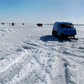
Location ID: #9247
20 photos
Good sized marina, boat and snowmobile storage and repair. Large shop and office area. Airplane, 2 bombardier “snow tracks” (from 1957 and 1949). 14 uniform and good sized ice fishing huts.
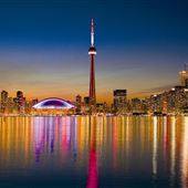
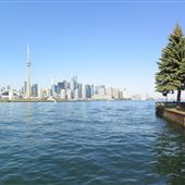
Location ID: #6213
2 photos
Various skyline images.
Location ID: #2685
94 photos
Established in 1972. Natural area often used by film companies for period camps or lakefront river front look. Flat fields next to marsh lake area. Over 600 hectare wildlife sanctuary operated by Royal Botanical Gardens. 320 hectare river ...
Location ID: #4293
19 photos
672 acres. Includes cranberry marsh with viewing platforms and boardwalk. Wooded areas with paths.
Location ID: #4413
18 photos
100 acre wildlife reserve open to the public but created by GM. 7 km of walking trails through varied terrain, wildlife reserve, waterfront trail, marsh, wetlands, ponds, rivers, streams, observation decks, boardwalks, various wooden and steel ...
Location ID: #13444
161 photos
472 hectare park includes extensive wetlands, forest, fields and a large reservoir. 16 km of forest and lakeshore trails, visitor’s centre, 180 year old farmhouse, Douglas G Cockburn Raptor Centre, play barn, observation towers, horse drawn wagon ...
Location ID: #5212
16 photos
Lakefront marsh with a variety of wildlife and plants. Access via Jack Darling Park. Environmentally sensitive wetland with raised boardwalks, stairs and bridge. 94 acres.

Location ID: #10106
25 photos
Algonquin Provincial Park is a provincial park located between Georgian Bay and the Ottawa River mostly within the Unorganized South Part of Nipissing District. Established in 1893, it is the oldest provincial park in Canada. Additions since its ...
Location ID: #6654
39 photos
Wye Marsh, and its interpretive centre, sits on a 3,000-acre wildlife area situated in an environmentally endowed location in southern Georgian Bay. Wildlife sanctuary. Ponds and canoeing channels. Floating boardwalk. Trails through marsh and ...
Location ID: #2005
4 photos
Part of Hamilton Conservation Authority. Beverly Swamp is at an elevation of 265 to 270 meters above sea level. 20 square kilometers. Swamp area with dirt road. Small pond. Road with bridge. 7 km paved safari road. See linked website for ...
Location ID: #5283
110 photos
Part of historic Rideau Canal Waterway which connects Kingston in the south to Ottawa in the north, 125 miles long, varies in width and depth. Canal and locks built 1826 to 1832, 45 locks in 23 lock stations, operated by Parks Canada. Waterway ...
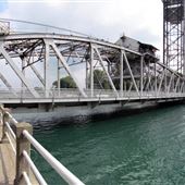
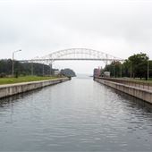
Location ID: #6504
65 photos
Built from 1829 to 1932. Connects Lake Ontario to Lake Erie. 8.2m deep & 42 km long from Port Weller to Port Colborne. 8 ship locks, 1-7 lift locks. Lock 8 is regulating lock and one of world’s longest lock canals. 11 rail / car bridges cross ...
Location ID: #5001
7 photos
Largest hydraulic lift lock in the world, operating on balance principle. Built of concrete. Opened July 9, 1904. Richard Birdsall Rogers designer. Lock 19 is on the Trent-Severn Canal at the south end of Peterborough. Wide river with a dam. ...
Location ID: #4023
21 photos
Canal. Locks.
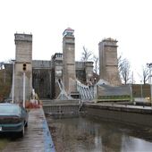
Location ID: #9942
36 photos
Completed in 1895, the Sault Ste Marie canal formed the last link in an all-Canadian navigation system stretching from the St. Lawrence River to Lake Superior. Closed in 1987 due to a lock wall failure, the canal was equipped with a modern lock and ...
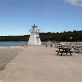
Location ID: #4219
6 photos
Small white clapboard lighthouse with red trim at entrance to marina, built in 1903 restored 1983. Overlooks high cliffs along Georgian Bay and modern Lion’s Head Marina.
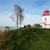
Location ID: #2256
24 photos
Red and white clapboard lighthouse built in 1896. Situated on cliff overlooking Georgian Bay. Period living quarters and access to 3rd floor light room. On site lightkeepers cottage occupied by full time lightkeeper. Wingfield Bay is natural ...
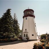
Location ID: #18870
26 photos
Built in 1847, the 33' tall lighthouse stands 140' above Lake Huron. Surrounded by a small park set above the Main Beach. Stair access to St. Christopher's Beach from the lighthouse. Goderich Harbour Lookout and Sunset Lookout have stair access to ...
Location ID: #19913
18 photos
This lighthouse replica was constructed in 1989 and is run by the local Rotary club. It currently serves as the Prescott Visitor Center. There is a small ice cream stand and gift shop in the base of the structure, and visitors can climb up to the ...
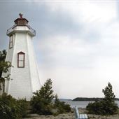
Location ID: #6192
11 photos
White woodframe lighthouse with red trim. Height 43 ft. Sits on rocky point of land surrounded on one side by mature evergreen trees. Rocky coastline. Parking lot is hidden but close to structure.
Location ID: #6237
247 photos
Toronto Islands include Centreville, Centre Island, and Algonquin. Centreville is an amusement park for young children that features scaled down period buildings, water play area, log ride, train ride, and working farm. Centre Island has docks, ...